

Published
Aoraki/Mount Cook key facts
- Height: 3,724 m (12,218 ft), measured by GPS in November 20131.
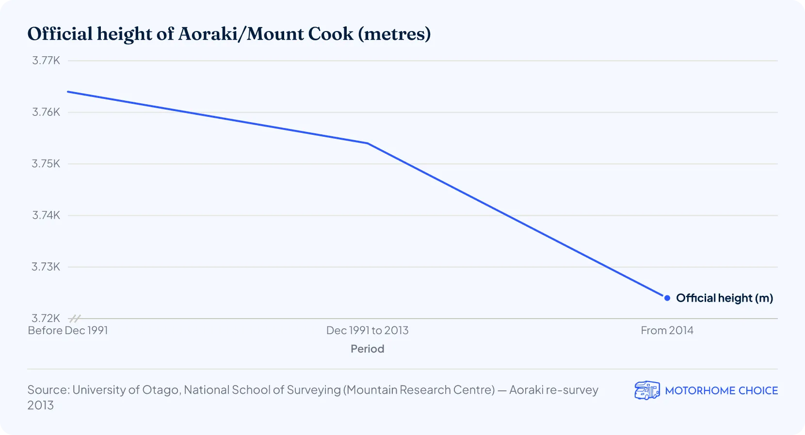
- Height lost: 30 m lower than the 3,754 m official height used from 1991 to 20141.
- High peaks: 19 peaks over 3,000 m (9,840 ft) in the national park2.
- Glaciers: cover 40% of Aoraki/Mount Cook National Park2.
- Tasman Glacier: 23 km (14 miles) long, New Zealand’s longest glacier2.
- Visitors: more than a million a year (August 2026)3.
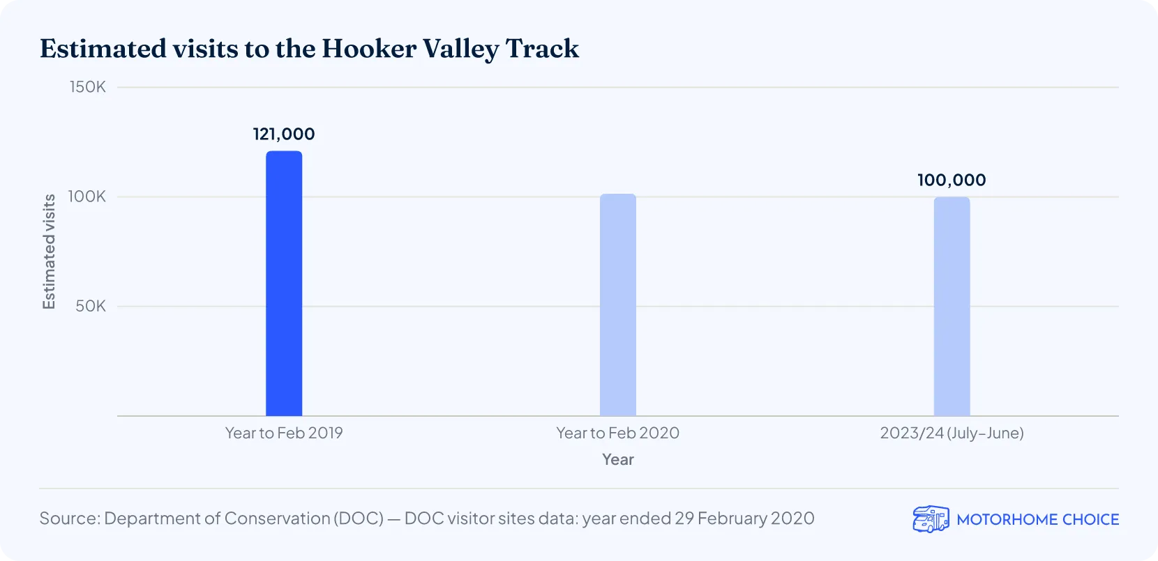
- Hooker Valley Track: more than 100,000 people visited in the 2023/24 financial year4.
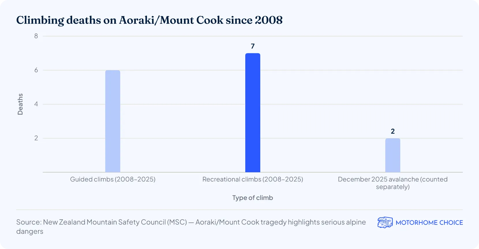
- Climbing deaths: 13 on Aoraki/Mount Cook from 2008, when comprehensive records began, plus 2 more in an avalanche in December 20255.
How tall is Aoraki/Mount Cook?
Aoraki/Mount Cook is 3,724 metres (12,218 feet) high, according to high-accuracy GPS readings taken by a University of Otago expedition on 23 November 20131. The survey team’s results, published on 26 January 2014, matched aerial-photo calculations from a 2008 survey, and Land Information New Zealand (LINZ) said it would use the new height in its online data and maps. The Department of Conservation (DOC) gives the same 3,724 m height today2.
Before the resurvey the official height was 3,754 metres (12,316 feet), a figure estimated from aerial photographs taken just after the summit collapsed on 14 December 19911. The new GPS measurement was only the sixth accurate survey of the mountain’s height from the ground, after trigonometric surveys in 1851, 1879, 1881, 1883 and 1889. To respect Aoraki’s tapu status, agreed with Ngāi Tahu, the climbers took their readings a few metres below the true summit rather than standing on it.
Aoraki/Mount Cook is still New Zealand’s highest mountain, 227 m (745 ft) taller than the second highest, Rarakiroa/Mount Tasman, which has an official height of 3,497 m (11,473 ft)1.
Why did Aoraki/Mount Cook get shorter?
Aoraki/Mount Cook lost about 40 metres in two stages: about 10 metres in the rock fall of 14 December 19916 and another 30 metres as the remaining ice cap wore away over the next two decades1.
DOC’s 2004 management plan says the 1991 rock fall sent 14 million cubic metres of rock and ice down onto the Grand Plateau and across the Tasman Glacier6. The debris travelled 7.3 kilometres (4.5 miles) at speeds of up to 600 km/h (370 mph). The Otago researchers put the later 30-metre drop down to the slow erosion of a thick ice cap left out of balance with the new summit ridge: most likely a change in the mountain’s shape rather than an effect of climate change1.
| Aoraki/Mount Cook height timeline, 1851–2014 | |
|---|---|
| Date | Event |
| 1851 | Captain J. L. Stokes names the mountain Mount Cook, after Captain James Cook; first of five trigonometric height surveys made between 1851 and 188921 |
| 14 Dec 1991 | Rock and ice collapse removes the top 10 m; official height becomes 3,754 m61 |
| 2008 | Aerial survey suggests the summit is tens of metres lower than the official height1 |
| 23 Nov 2013 | University of Otago team takes GPS readings near the summit1 |
| 26 Jan 2014 | New height of 3,724 m published1 |
Source · DOC; University of Otago (January 2014); DOC, Aoraki/Mount Cook National Park Management Plan 2004
How many peaks over 3,000 metres are in Aoraki/Mount Cook National Park?
There are 19 peaks over 3,000 metres (9,840 feet) in Aoraki/Mount Cook National Park, including Aoraki/Mount Cook itself, according to DOC2.
The park was declared a national park in 1953, though its core was first protected in 1885, and in 2004 it covered 70,728 hectares (707 km², or 273 square miles)6. It is part of Te Wāhipounamu – South West New Zealand World Heritage Area2. DOC records more than 300 species of plants in the park, including the Mount Cook lily (Ranunculus lyallii), the largest buttercup in the world, and about 40 species of birds, among them the kea, an alpine parrot.
How much of Aoraki/Mount Cook National Park is covered by glaciers?
Glaciers cover 40% of Aoraki/Mount Cook National Park, according to DOC2: about 283 km² (109 square miles) of the park’s 707 km²6.
Five major glacier valley systems have shaped the park: the Godley, Murchison, Tasman, Hooker and Mueller2. The largest glacier, the Haupapa/Tasman Glacier, is visible from the highway at the park entrance.
| Haupapa/Tasman Glacier in figures | |
|---|---|
| Haupapa/Tasman Glacier | Figure |
| Length | 23 km (14 miles), New Zealand’s longest glacier2 |
| Width | Up to 3 km (1.9 miles)2 |
| Area | 101 km² (39 square miles)2 |
| Ice depth | About 600 m (1,970 ft) near the Hochstetter Icefall2 |
Source · DOC, Aoraki/Mount Cook National Park (October 2026)
How big is Tasman Lake?
Tasman Lake covered 5.96 square kilometres (2.3 square miles) in May 2008 and was up to about 240 metres (790 feet) deep, according to a peer-reviewed study of satellite images published in 20117.
The lake at the end of the Tasman Glacier began forming in 1974 and has grown steadily since; it is now large enough for commercial boat and kayak tours8. Between 2000 and 2008 the glacier’s front retreated by up to about 3.7 km7.
| Tasman Lake growth, 1974–2008 | ||
|---|---|---|
| Tasman Lake | Figure | Year |
| Began forming | – | 19748 |
| Surface area | 3.7 km² (1.4 sq mi) | 20037 |
| Surface area | 5.96 km² (2.3 sq mi) | May 20087 |
| Average growth | 0.34 km² a year | 2000–20087 |
| Maximum depth | About 240 m (790 ft) | 20087 |
| Volume | 510 million m³ | 20087 |
Source · DOC, Tasman Lake and River Track; Arctic, Antarctic, and Alpine Research, vol. 43 (2011)
The water is typically about 3 °C (37 °F), and DOC warns visitors to stay out of the lake and off it when it freezes in winter8.
How many people visit Aoraki/Mount Cook each year?
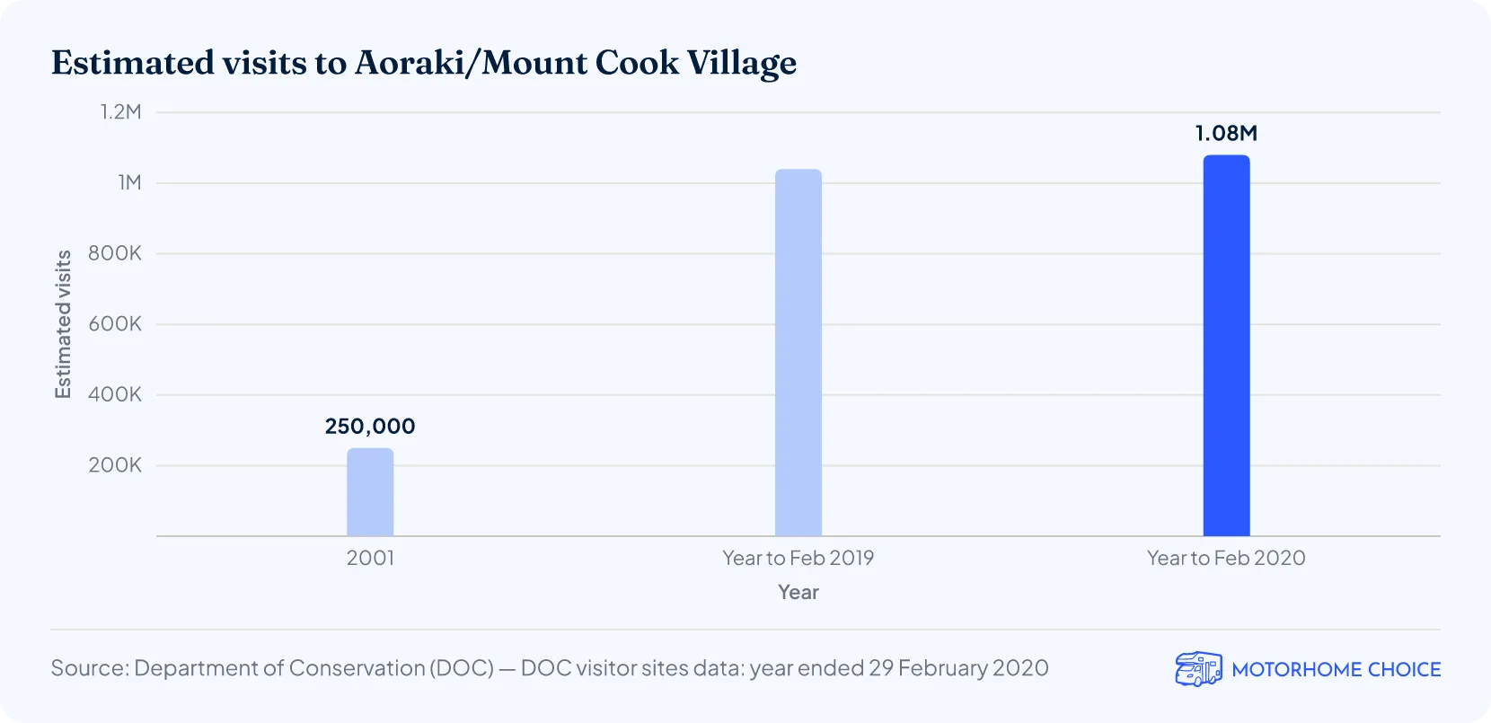
More than a million people visit Aoraki/Mount Cook each year, DOC said in August 20263. DOC estimated more than 1.08 million visits to Aoraki/Mount Cook Village in the year to 29 February 2020, up 4% on the year before and 33% on 2016/179.
That is nearly 3,000 visits a day on average, and more than four times the 250,000-plus visits a year DOC estimated for 20016, though the two estimates were made in different ways. DOC’s 2004 plan said about 70% of visits were by overseas tourists and 67% were day visits.
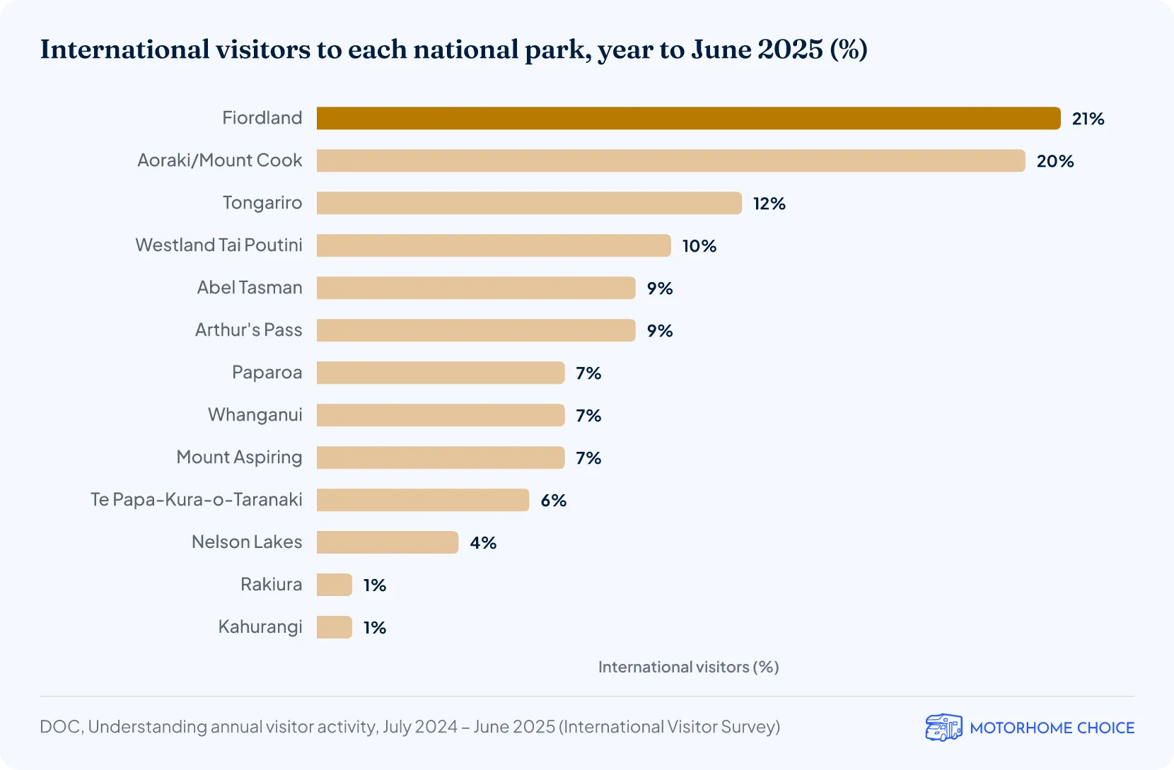
In the year to June 2025, 20% of New Zealand’s 3.4 million international visitors went to Aoraki/Mount Cook National Park, second only to Fiordland at 21%10. By our calculation, that is roughly 680,000 international visitors. Among New Zealanders, Aoraki/Mount Cook was the third most visited national park in the same year, after Tongariro and Abel Tasman.
The park is at the end of State Highway 80, about a 4.5-hour drive from Christchurch and 3.5 hours from Queenstown; the nearest towns with supermarkets are Twizel, an hour away, and Lake Tekapo, an hour and a half2. If your trip starts with campervan hire in Christchurch, check the road before you set out in winter: DOC warns that access may be limited by snow from June to September.
How many people walk the Hooker Valley Track?
More than 100,000 people visited the Hooker Valley Track, the park’s most popular attraction, in the 2023/24 financial year, according to DOC4. In 2019/20 it drew 101,500 visits, roughly one in ten of the village’s 1.08 million9.
The track is 10 kilometres (6.2 miles) return from White Horse Hill car park to Hooker Lake11, and DOC suggests allowing 3–4 hours2. A new 189-metre (620-foot) suspension bridge over the Hooker River, the longest in New Zealand, opened in July 2026, replacing a swing bridge closed by riverbank erosion113. DOC says the track is busiest between 10 am and 4 pm4.
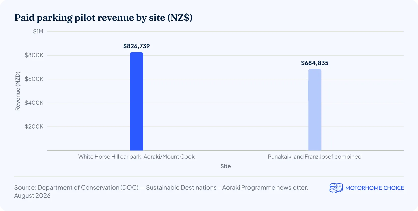
Parking at White Horse Hill costs NZ$2.50 per half hour or NZ$25 a day, and is free if you arrive and leave within 20 minutes (October 2026)11. During a seven-month paid parking pilot, the car park raised NZ$826,739 from 56,438 transactions, the most of the three pilot sites, and DOC has kept the charges3. By our calculation that is an average of NZ$14.65 per transaction, and 55% of the NZ$1,511,574 raised across all three sites.
How many climbers have died on Aoraki/Mount Cook?
Thirteen climbers died on Aoraki/Mount Cook from 2008, when comprehensive records began, to December 2025 (six on guided climbs and seven on recreational climbs), according to the New Zealand Mountain Safety Council (MSC)5. Two more climbers were believed killed in a large ice fall avalanche on the mountain in December 2025.
That makes at least 15 deaths on the mountain itself (not the whole national park) since 2008, a little under one a year on average5.
| Climbing deaths on Aoraki/Mount Cook, 2024–2025 | ||
|---|---|---|
| Date | Deaths | What happened |
| December 2024 | 3 | Three climbers, including two guides from the US and Canada, died while climbing the mountain; their bodies were never recovered12 |
| 24 November 2025 | 2 | A guide and their client fell near the summit during a grand traverse12 |
| December 2025 | 2 | Two missing climbers were believed to have been caught in a large ice fall avalanche; Police said it was not survivable5 |
Source · New Zealand Mountain Safety Council (25 November and 19 December 2025)
How big is the Aoraki Mackenzie International Dark Sky Reserve?
The Aoraki Mackenzie International Dark Sky Reserve covers 4,367 square kilometres (1,686 square miles), taking in Aoraki/Mount Cook National Park and the Mackenzie Basin, according to the reserve13. That is about six times the size of the national park.
The reserve was created in 2012 with accreditation from DarkSky International, the third such reserve recognised in the world13. It is the largest in the Southern Hemisphere and the third largest in the world, and its night skies rate Bortle class 2, close to pristine. It includes Lake Tekapo, the Godley Valley and Lake Pūkaki (Pukaki).
More New Zealand facts & statistics
Campervan hire in New Zealand
References
- Aoraki re-survey 2013 (University of Otago, National School of Surveying)otago.ac.nzPublished 2014-01-26 · Retrieved 2026-10-14
- Sustainable Destinations – Aoraki Programme newsletter, August 2026 (DOC)doc.govt.nzPublished 2026-08-01 · Retrieved 2026-10-14
- Let's care for Aoraki this summer (DOC media release, 20 December 2024)doc.govt.nzPublished 2024-12-20 · Retrieved 2026-10-14
- Aoraki/Mount Cook tragedy highlights serious alpine dangers (New Zealand Mountain Safety Council)mountainsafety.org.nzPublished 2025-12-19 · Retrieved 2026-10-14
- Aoraki/Mount Cook National Park Management Plan 2004 (DOC)doc.govt.nzPublished 2004-08-01 · Retrieved 2026-10-14
- Twenty-First Century Calving Retreat of Tasman Glacier, Southern Alps, New Zealand (Arctic, Antarctic, and Alpine Research, vol. 43, no. 1)tandfonline.comPublished 2011-01-01 · Retrieved 2026-10-14
- DOC visitor sites data: year ended 29 February 2020doc.govt.nzPublished 2020-01-01 · Retrieved 2026-10-14
- MSC & NZMGA respond to Aoraki Mount Cook climbing tragedy (New Zealand Mountain Safety Council)mountainsafety.org.nzPublished 2025-11-25 · Retrieved 2026-10-14
- The Reserve (Aoraki Mackenzie International Dark Sky Reserve)darkskyreserve.org.nzRetrieved 2026-10-14