

Published
Key facts
- About 20,700 earthquakes were located by GeoNet in the New Zealand region in 2025 (our count)1.
- 50 to 80 earthquakes a day, or about 20,000 a year, is GeoNet's long-run figure2.
- About 41 earthquakes of magnitude 5 to 5.9 strike each year, and one of magnitude 7 or more every four years (GeoNet averages since 1960)3.
- Magnitude 8.2 was the Wairarapa earthquake of 23 January 1855, the largest since European colonisation began in 18404.
- 256 people were killed in the 1931 Hawke's Bay (Napier) earthquake, the deadliest on record (3 February 1931)5.
- 185 people died in the Christchurch earthquake (22 February 2011)6.
- More than 20 faults ruptured in the magnitude 7.8 Kaikōura (Kaikoura) earthquake, a world record (14 November 2016)7.
- 75% probability of an Alpine Fault earthquake occurring in the next 50 years, and a 4 out of 5 chance that it will be a magnitude 8+ event, according to AF8, based on a 2021 study89.
How many earthquakes does New Zealand have a year?
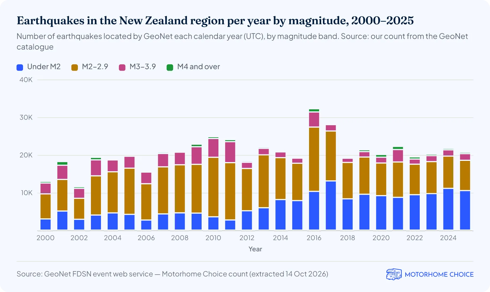
GeoNet located 20,659 earthquakes in the New Zealand region in 2025, by our count of its catalogue1. From 2000 to 2025 the count averaged about 20,600 a year, in line with GeoNet's figure of about 20,000 a year2.
- The busiest year was 2016, with 32,207 earthquakes1, the year of the magnitude 7.8 Kaikōura earthquake and its aftershocks.
- The quietest year was 2002, with 11,5201. GeoNet notes that its network could not detect every small earthquake in earlier years3, so part of the rise since then reflects better detection rather than more shaking.
- From January to September 2026, GeoNet located 16,030 earthquakes (our count)1.
- In the 365 days to 14 October 2026, GeoNet's statistics page counted 22,106 earthquakes2.
How many earthquakes are there in New Zealand each day?
How often does New Zealand have a big earthquake?
New Zealand has about 41 earthquakes of magnitude 5 to 5.9 a year, about 1.9 of magnitude 6 to 6.9 and one of magnitude 7 or more every four years, according to GeoNet's records since 19603. GeoNet puts magnitude 8 earthquakes at about one a century, based on geological and historical evidence.
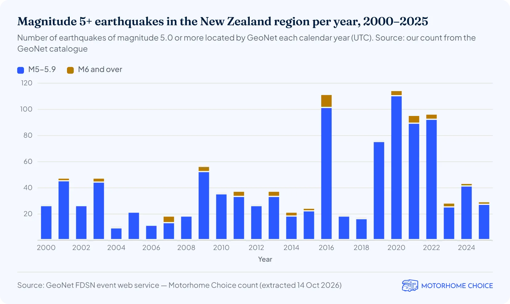
- Our count of GeoNet's catalogue found 1,091 earthquakes of magnitude 5 or more in 2000–2025, about 42 a year1.
- 2020 had the most, 1141. Next was 2016, the year of the East Cape and Kaikōura earthquakes, with 111, including 10 of magnitude 6 or more.
- 2019–2022 were all busy years, with 76 to 114 a year in our count1. GeoNet's long-term table shows the same rise, with 69 to 98 earthquakes of magnitude 5 to 5.9 a year3.
- In 2025 there were 29 earthquakes of magnitude 5 or more, two of them magnitude 6 or more1.
| How often New Zealand has earthquakes of each size (yearly averages since 1960) | ||||
|---|---|---|---|---|
| Magnitude | Average a year | Fewest in a year | Most in a year | In general |
| 4.0–4.9 | 3983 | 178 | 1,178 | 1 a day |
| 5.0–5.9 | 41 | 9 | 113 | 3 a month |
| 6.0–6.9 | 1.9 | 0 | 9 | 2 a year |
| 7.0–7.9 | 0.26 | 0 | 2 | 1 every 4 years |
| 8.0 or over | 0 | 0 | 0 | 1 a century*3 |
Source · GeoNet, Earthquake Statistics: Long Term (New Zealand region, 1960 onwards), 14 October 2026. The "In general" entries for magnitude 5 and 6 are rounded from the averages. *Based on geological investigations and the historical record of earthquakes.
What was the biggest earthquake in New Zealand?
The biggest earthquake in New Zealand since European colonisation began in 1840 was the magnitude 8.2 Wairarapa earthquake of 23 January 1855 (moment magnitude 8.2–8.3), according to GeoNet4. It killed between 7 and 9 people and was highly destructive in Wellington.
- It raised the ground by 2.7 m (9 ft) at Muka Muka, on the western side of Palliser Bay, and lifted land around Wellington Harbour; Wellington's Basin Reserve sports ground sits on land raised by the earthquake4.
- The next largest in GeoNet's list of historical earthquakes are the magnitude 7.8 Kaikōura earthquake of 2016 and the magnitude 7.8 Dusky Sound (Fiordland) earthquake of 200910.
- The magnitude 8.1 Kermadec Islands earthquake of 5 March 2021 struck 1,025 km (637 miles) north-east of Whangārei (Whangarei)11, outside the New Zealand region GeoNet uses for its statistics.
- Before written records, the last big Alpine Fault earthquake, in 1717, is estimated at magnitude 8.18.
| Magnitude 7.2 or larger earthquakes in GeoNet's historical earthquake list, 1840–2026 | |||
|---|---|---|---|
| Rank | Date | Earthquake | Magnitude |
| 1 | 23 Jan 1855 | Wairarapa | 8.24 |
| 2= | 14 Nov 2016 | Kaikōura | 7.87 |
| 2= | 15 Jul 2009 | Dusky Sound (Fiordland) | 7.812 |
| 4= | 3 Feb 1931 | Hawke's Bay (Napier) | 7.45 |
| 4= | 16 Oct 1848 | Marlborough | 7.413 |
| 6 | 17 Jun 1929 | Buller (Murchison) | 7.314 |
| 7= | 5 Mar 2021 | East Cape | 7.210 |
| 7= | 4 Sep 2010 | Darfield (Canterbury) | 7.215 |
| 7= | 22 Aug 2003 | Fiordland | 7.210 |
| 7= | 5 Mar 1934 | Horoeka (Pahiatua) | 7.210 |
| 7= | 19 Oct 1868 | Cape Farewell | 7.210 |
Source · GeoNet earthquake stories, headline magnitudes, 14 October 2026. New Zealand dates.
What was the deadliest earthquake in New Zealand?
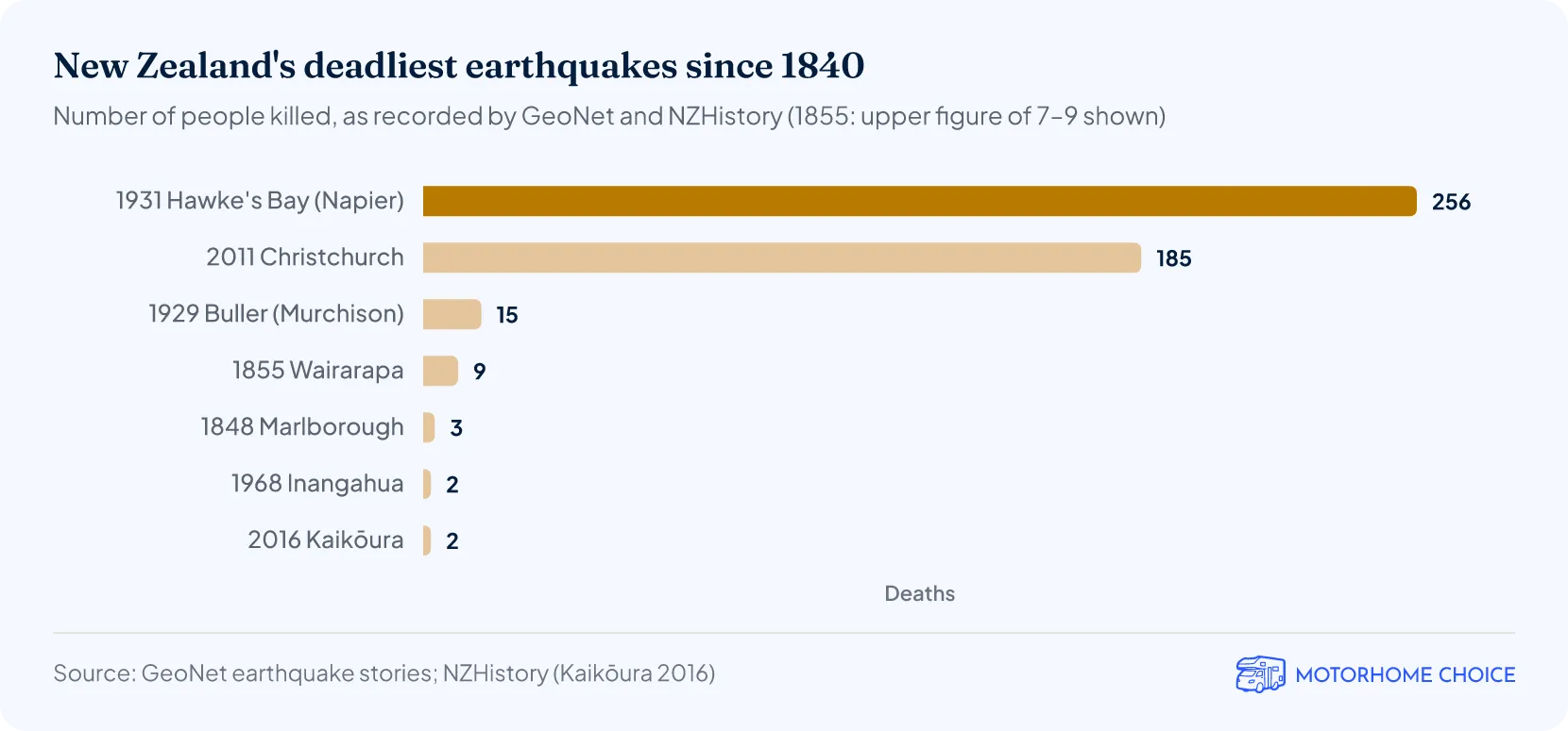
New Zealand's deadliest earthquake was the Hawke's Bay (Napier) earthquake of 3 February 1931, which killed 256 people (the official toll) and seriously injured 593, according to GeoNet5. GeoNet lists it as magnitude 7.4: moment magnitude 7.4–7.6, or 7.8 on the older surface-wave scale.
- It struck at 10:47 a.m., and fires in the business areas of Napier and Hastings became uncontrollable as broken water mains cut the water pressure5.
- The land rose by up to 2.7 m (9 ft) near the mouth of the Arapaoanui River, while parts of Hastings sank by up to 1 m (3 ft)5.
- The second deadliest, the Christchurch earthquake of 22 February 2011, killed 185 people6.
- The 1929 Buller (Murchison) earthquake killed 15 people, a number of them overwhelmed by landslides14.
| Earthquakes that killed people in New Zealand, 1840–2026 (GeoNet's historical list) | |||
|---|---|---|---|
| Date | Earthquake | Magnitude | Deaths |
| 3 Feb 1931 | Hawke's Bay (Napier) | 7.4 | 2565 |
| 22 Feb 2011 | Christchurch | 6.2 | 1856 |
| 17 Jun 1929 | Buller (Murchison) | 7.3 | 1514 |
| 23 Jan 1855 | Wairarapa | 8.2 | 7–94 |
| 16 Oct 1848 | Marlborough | 7.4 | 3 (in the largest aftershock, 17 Oct)13 |
| 24 May 1968 | Inangahua | 7.1 | 216 |
| 14 Nov 2016 | Kaikōura | 7.8 | 217 |
| 24 Jun 1942 | Wairarapa | 6.9 | 118 |
| 20 Dec 2007 | Gisborne | 6.7 | 1 (heart attack)19 |
Source · GeoNet earthquake stories; NZHistory, Ministry for Culture and Heritage (Kaikōura 2016). New Zealand dates; GeoNet headline magnitudes.
How many people died in the Christchurch earthquake?
185 people died in the Christchurch earthquake of 22 February 2011, according to GeoNet6. GeoNet lists it as magnitude 6.2 (local magnitude 6.3).
- It was centred within 10 km (6 miles) of the city at a shallow depth of 5 km (3 miles), and struck in the middle of a working day6.
- It followed the magnitude 7.2 Darfield (Canterbury) earthquake of 4 September 2010, which caused severe building damage but no loss of life: it struck at 4:35 a.m., when the central city streets were deserted15.
How big was the Kaikōura earthquake?
The Kaikōura earthquake of 14 November 2016 was magnitude 7.8, and it ruptured more than 20 different faults (a world record) along about 180 km (112 miles) of the north-east South Island, according to GeoNet7.
- It struck at 12:02 a.m. local time, 15 km (9 miles) north-east of Culverden in North Canterbury, starting near the town of Waiau7.
- The rupture lasted nearly two minutes and moved the ground by up to 12 m (39 ft), sideways and up or down7.
- It triggered the biggest local-source tsunami recorded in New Zealand since 19477.
- Two people died: one from a heart attack at Mt Lyford and one when a homestead collapsed in Kaikōura17.
What is the Alpine Fault, and how likely is a big earthquake?
AF8 (Alpine Fault magnitude 8) says there is a 75% probability of an Alpine Fault earthquake occurring in the next 50 years, and a 4 out of 5 chance that it will be a magnitude 8+ event9.
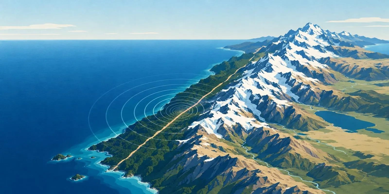
- The Alpine Fault is more than 850 km (530 miles) long and marks where the Australian and Pacific plates meet and grind against each other, forcing up the Southern Alps8.
- Its last big earthquake, in 1717, is estimated at magnitude 8.1 and ruptured about 380 km (236 miles) of the fault8.
- Sediments in four West Coast lakes and two swamps record 20 earlier Alpine Fault earthquakes over the past 4,000 years, some of them magnitude 7 ruptures that stopped partway along the fault8.
- The odds come from a 2021 study led by Te Herenga Waka—Victoria University of Wellington; before it, the chance had been thought to be about 30%8.
- Large earthquakes on the fault have come at intervals of around 300 years on average, according to Otago Regional Council20.
- Otago Regional Council points people to getready.govt.nz for advice on preparing for a big earthquake20; read it before touring the South Island with campervan hire in New Zealand.
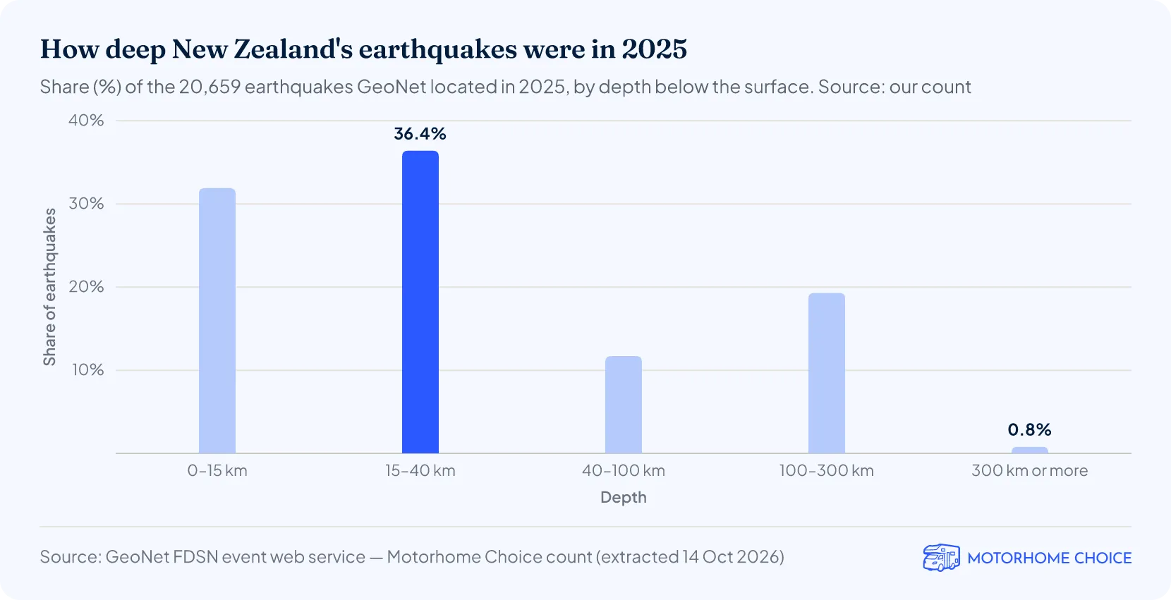
How deep are New Zealand's earthquakes?
Half of the earthquakes GeoNet located in New Zealand in 2025 were shallower than 24 km (15 miles), by our count1, and 68% were 40 km (25 miles) deep or shallower.
More New Zealand facts & statistics
Campervan hire in New Zealand
References
- GeoNet: Earthquake Statistics – Long Term (New Zealand region, 1960 onwards)geonet.org.nzRetrieved 2026-10-14
- Alpine Fault quake risk higher than experts thought (Te Herenga Waka—Victoria University of Wellington, 20 April 2021)wgtn.ac.nzPublished 2021-04-20 · Retrieved 2026-10-14
- GeoNet: Earthquake stories – New Zealand's significant historical earthquakesgeonet.org.nzRetrieved 2026-10-14
- Kaikōura earthquake (NZHistory, Ministry for Culture and Heritage)nzhistory.govt.nzRetrieved 2026-10-14